Abgrenzung versiegelter Flächen von bewachsenen Flächen im Luftbild und als GIS Datensatz mit Angabe der Größe in Quadratmetern.
Überlagerung mit Katasterkarte, um die Größe und den prozentualen Anteil der versiegelten Fläche für jedes Flurstück zu ermitteln.
Darstellung der Ergebnisse (Luftbildkarte mit versiegelten und bewachsenen Flächen und mit Flurstücksgrenzen und Nummern) im Internet mit autorisiertem Zugang falls erwünscht.
Optional: automatische Erfassung von Bäumen mit genauem Standort und Baumhöhe (x/y/z-Koordinaten für jeden Baum) sowie einer groben Einschätzung des Gesundheitszustandes.
Fallbeispiel:
linkes Bild: Original
Luftbild
rechtes Bild: versiegelte Flächen in lila
Automatic Mapping of Forest Succession
Automatische Kartierung von Natürlicher Sukzession auf landwirtschaftlichen Flächen
Ehemals landwirtschaftlich genutzte Flächen werden nach der Aufgabe der Bewirtschaftung früher oder später wieder zu Wald. Um diese Flächen offen zu halten, müssen rechtzeitig entsprechende Pflegemaßnahmen geplant werden. Gleichzeitig erlischt für die nicht mehr bewirtschafteten Flächen ein etwaiger Anspruch auf landwirtschaftliche Subventionen.
landConsult`s Partnerbüro ProGea hat als Kontrollinstrument ein Verfahren entwickelt, dass es ermöglicht, Flächen im Anfangsstadium der natürlichen Wiederbewladung automatisch aus Luft- oder Satellitenbilder zu erkennen und in ein GIS zu übertragen.
Auf großer Fläche können mit diesem standardisierten Verfahren betroffene Gebiete nachvollziehbar kartiert und durch die Überlagerung mit der Katasterkarte der Eigentümer ermittelt werden.
Leistung:
Geographische Erfassung (x/y-Koordinaten) und genaue Flächenermittlung von ehemals landwirtschaftlich genutzten Flächen mit einsetzender natürlicher Sukzession.
Überlagerung mit Katasterkarte und parzellenscharfe Abgrenzung der betroffenen Flächen.
Darstellung der Ergebnisse mit Luftbildkarte und forstlichem GIS Daten im Internet mit autorisiertem
Zugang falls erwünscht.
Fallbeispiel:
Download Article: "Automatic mapping of the dynamics of forest succession on abandoned parcels in south Poland" Acrobat PDF File (0.5. MB)
Download compressed Presentation as PDF: Acrobat PDF File (4,7 MB)
Download original Presentation: Powerpoint Präsentation (50 MB!)
Literatur/Link Hinweis:
de Kok, R., Wezyk, P. (2005): Automatic Mapping of the Dynamics of Forest Succession on Abandonned Parcels in South Poland. Beitrag zur AGIT Symposium in Salzburg.
landConsult and CyperCat
Computer gestützte "Go/NoGo" Geländeanalysen für autonom gesteuerte Fahrzeuge.
Leistung:
Abgrenzung von befahrbaren Flächen von unbefahrbaren Flächen im
Luftbild und als GIS Datensatz mit Angabe der Flächengröße und Landnutzung.
Darstellung der Ergebnisse in einer Luftbildkarte mit befahrbaren und unbefahrbaren Flächen.
Automatische Erfassung von Bäumen mit genauem Standort und Baumhöhe (x/y/z-Koordinaten für jeden Baum).
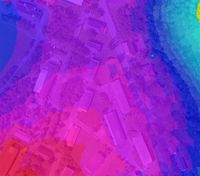
Abbildung 2: Auswertung der First Pulse Laserdaten zur Darstellung des Oberfächenmodells (dunkelgrün = hoch, blau = ohne Echo, z.T. Wasserflächen).
Abbildung 3: Differenzmodell aus First Pulse und Last Pulse Laserdaten
Abbildung 4: Kantendetektion aus Bild- und Laserdaten generiert
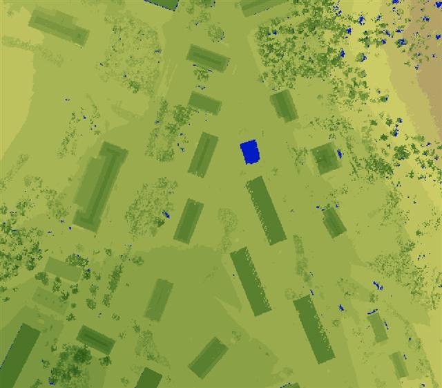
Abbildung 5: Automatisierte Erfassung und Darstellung der "GO" Bereiche, d.h. des befahrbaren Geländes (im Bild mit weißen Punkten dargestellt).
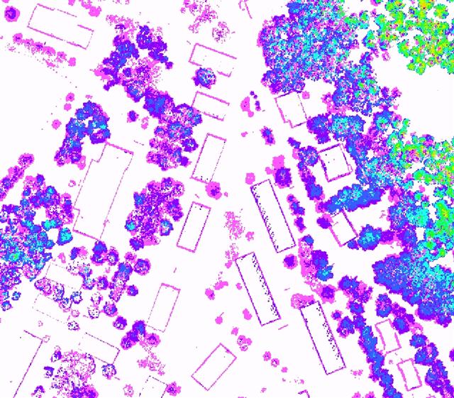
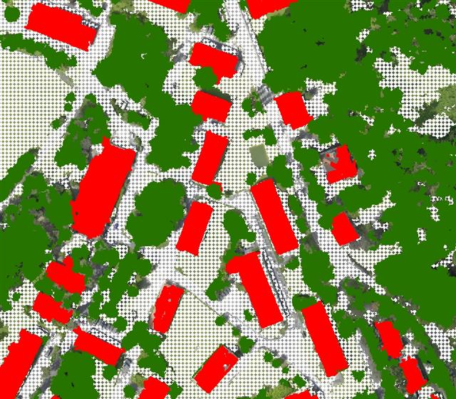
Abbildung 6: Automatisierte Erfassung und Darstellung von Gebäuden (rot) und Bäumen (grün) als Teil der "NoGo" Bereiche, d.h. des nicht passierbaren Geländes.
CyperCat is an open information system that can be composed of many different
databases on different servers at different places of the world.
All databases contain information about information, called Metadata.
It`s interactive
CyperCat is an interactive system, i.e. you can set up your own Metadata
Information System using a common web browser, like the MS Internet Explorer,
providing an enter and serach functionality to your users.
The results of the search include an active hyperlink to download or display the
original data file on your computer.
It`s standardised
CyperCat is using standardised databases with fields (or columns) that have been
developed by an international initiative called
the Dublin Core Initiative . This standard grants for a high transparency and
international integration of your metadata.
It`s flexible
The DublinCore standard is a very flexible way to describe your work, i.e. you can use
it to structure all kinds of products, like publications, maps, reports, web sites, but
also physical places like nature protected areas or events and services like recreation
facilities in a nature park.
It`s distributed
CyperCat is based on the idea of a distributed database management, e.g. the system
can search on distributed databases to find the right information. If you want to read more
about the vision and the technical concept of CyperCat please
click here.
Ein Geographisches Informations- und Geschichtenbuch der anderen Art
Das Projekt "Menschen am Fluß" ist ein Bürgerprojekt in Zusammenarbeit mit der Arbeitsgemeinschaft "Flößerpfad an der Kinzig", dem Schwarzwaldverein sowie den Naturpark Initiativgemeinden Alpirsbach und Loßburg.
Die virtuelle Version des "Flößerpfades an der Kinzig" ergänzt die bekannten historischen Fakten durch eigene persönliche Erinnerungen. Die Webseite dient hierbei als ein "offenes Geschichtenbuch", in das historisches Wissen und persönliche Erlebnisse in Zusammenhang mit der Kinzig und der Lohmühle orts- und zeitbezogen eingetragen und abgefragt werden können.
Die Geschichten, die hier erzählt werden, besitzen also immer zwei Bezugspunkte: einen zeitlichen und einen geographischen, das heißt jede Geschichte ist eine Reise in die Zeit und zugleich eine Reise entlang des Tales.
Eine mobile Ausführung des "Geschichtenbuches" für Wanderer ist geplant. Dafür werden die Geschichten der Webseite für einen mit einem GPS ausgestatteten PocketPCs aufbereitet und "verortet", damit wird für jeden Flussabschnitt in dem sich der Wanderer gerade befindet automatisch die richtige Geschichte im Display des PocketPC angezeigt.
landConsult and CyperCat
Computer Automated Detection of Sealed and Paved Sites, Overgrown Areas and Single Trees in an Urban Environment
Our Service:
Detailed automatic classification of urban sealed/paved sites and overgrown areas by means of aerial or satellite imagery.
GIS overlay with cadastral maps to accurately determine the percentage of sealed sites on each parcel.
Presentation of the results (classified sites with parcel borders and encoded parcel-id) on an Orthophoto Map and in GIS format, if required on a web based mapping system with authorised access.
Automatic detection of trees with specific location and tree height (x/y/z-coordinates) as well as a rough assessment of the tree health.
Automatic Detection and Mapping of Sites with Natural Succession on Arable Land
On abandoned arable land, the natural process of succession and re-forestation starts as soon as the agricultural management stops. These sites will become forests again, sooner or later. In order to keep such areas open, the necessary measures have to be taken in a timely manner. Otherwise, the areas may lose their legal eligibility to receive European agricultural subsidies.
landConsult`s partner ProGea has developed a control method, that can automatically detect the early stages of natural succession on arable land using airborne and/or satellite imagery.
Critical sites can easily be mapped in a reliable and effective way, by applying this standardised methodology to large areas. The visualisation in a GIS and the combination with cadastral data enables the user to quickly determine the owners of specific tracts of land.
Our Service:
Geographical recording (x/y-coordinates) and accurate detection of abandoned land (formerly managed agricultural land).
GIS overlay with cadastral data to determine land owners.
Presentation of results in an Orthophoto Map and on a web-based mapping system (MapServer or GoogleEarth), with authorised access if required.
Example:
Download Article: "Automatic mapping of the dynamics of forest succession on abandoned parcels in south Poland" Acrobat PDF File (0.5. MB)
Download compressed Presentation as PDF: Acrobat PDF File (4,7 MB)
Download original Presentation: Powerpoint Präsentation (50 MB!)
Literature and Links:
de Kok, R., Wezyk, P. (2005): Automatic Mapping of the Dynamics of Forest Succession on Abandoned Parcels in South Poland. Paper presented at the AGIT Symposium in Salzburg.
landConsult and CyperCat
Computer Based Automatic Go/NoGo Analysis of the Surrounding to Control Autonomous Vehicles.
Our Service:
Classification and automatic mapping of accessible sites and non-accessible areas in the aerial photo and as GIS data set with exact area size and land cover.
Visualisation in an Orthophoto Map
Automatic detection of trees with exact location and tree size
Figure 1: Original RGB Orthophoto from Image/Laser Flight
Figure 2: High Resolution Terrainmodell generated from Laser Point Cloud (blue = low, red = high)
Figure 3: Analysis of First Pulse Laserdata to visualise the Surface Modell (dark green = high, blue = no reflection, partly water bodies).
Figure 4: Deifference Modell generated from First Pulse and Last Pulse Laserdata
Figure 5: Edge Detection processed with Image- and Laserdata
Figure 6: Automatic Classification and Visualisation of "GO" Areas, i.e. of Terrain suitable for crossing with vehicles (illustrated with white dots).
Figure 7: Automatic Classification and Visualisation of buildings (red) and Trees (geen) as part of the "NoGo" Area, i.e. terrain unsuitable to cross with vehicles.
CyperCat is an open information system that can be composed of many different
databases on different servers at different places of the world.
All databases contain information about information, called Metadata.
It`s interactive
CyperCat is an interactive system, i.e. you can set up your own Metadata
Information System using a common web browser, like the MS Internet Explorer,
providing an enter and serach functionality to your users.
The results of the search include an active hyperlink to download or display the
original data file on your computer.
It`s standardised
CyperCat is using standardised databases with fields (or columns) that have been
developed by an international initiative called
the Dublin Core Initiative . This standard grants for a high transparency and
international integration of your metadata.
It`s flexible
The DublinCore standard is a very flexible way to describe your work, i.e. you can use
it to structure all kinds of products, like publications, maps, reports, web sites, but
also physical places like nature protected areas or events and services like recreation
facilities in a nature park.
It`s distributed
CyperCat is based on the idea of a distributed database management, e.g. the system
can search on distributed databases to find the right information. If you want to read more
about the vision and the technical concept of CyperCat please
click here.
An Interactive Geographic Information System and Open Story-Book for Local People
The project "Man and the River" ("Menschen am Fluß") is a "citizens" project in cooperation with the working group "Flößerpfad an der Kinzig (Raftsmen Trail along the River Kinzig)", the Black Forest Club, and the Nature Park communities of Alpirsbach and Loßburg.
The "Man and the River" Web site adds personal memories of local people to the well known historic facts of the Kinzig valley. The Web site works as an "Open Story-Book" to which everybody can add his historical knowledge as well as his personal experiences in the valley. This kind of information can be recorded and queried in a geo- and time-referenced manner.
Consequently the narrated stories always have two referencee points: a time related and a site related one, i.e. each story is a travel into history and at the same time a trip along the valley .
A mobile version of the "Story-Book" for hikers is planned. To do this, the stories of the web site will be prepared for a GPS controlled PocketPC (PDA). So the hiker will automatically receive the right story at the right place along his trip.